Description island ElbaThe inhabited large island of Elba (local name Isola d’Elba) is part of (the island group) Tuscan Archipelago and is located in the country of Italy, Southern Europe. The distance to the mainland is about 9.2 km. The surface-area of the island is 223.4 km2 and is therefore 0.588 x times greater than the island of Isle of Wight. The island lies in the Tyrrhenian Sea and the total coastal length is about 157.4 km and the dimensions of the island are approximately 28 km by 15 km (maximum width). The island is West - East oriented. The highest point is 1017 meter and is named Monte Capanne. The coordinates (latitude, longitude) of the island (center) for GPS are 42.78 (42°46'43.21), 10.29 (10°17'15.2232).The population is 32090 and the population density is thus on 139.00 inhabitants per square kilometer (compared Isle of Wight 364 inhabitants / km²). The capital of the island is Portoferraio (located in the North of the island). Other places on the island are: Rio Marina (O), Capoliveri (ZO), Campo nell’Elba (Z). The island is located in the Center of the country Italy. It is located in the administrative unit Region Tuscany (local administrative level-name regione), in the Province Livorno (local administrative level-name Provincia ). Direct neighboring islands of Elba are (distance from central part island to central part of the neighboring islands): 1) Pianosa Located 13.3 km WestSouthWest of the island. 2) Capraia Located 33.5 km SouthEast of the island. 3) Montecristo Located 40.5 km West of the island. 4) Corsica Located 50 km South of the island. 5) Del Giglio Located 51.5 km NorthWest of the island. 6) Gorgona Located 70.6 km EastSouthEast of the island. 7) Giannutri Located 74.4 km NorthWest of the island. 8) Isola Bisentina Located 121.3 km North of the island. 9) Isola Martana Located 125.6 km North of the island. 10) Isola del Tinetto Located 135.6 km EastSouthEast of the island. 11) Isola del Tino Located 135.8 km EastSouthEast of the island. 12) Palmaria Located 136.8 km EastSouthEast of the island. 13) Isola Maggiore Located 138.9 km NorthNorthEast of the island. 14) Isola Minore Located 139.9 km NorthNorthEast of the island. 15) Isola Polvese Located 140.8 km NorthNorthEast of the island. 16) Île Cavallo Located 167.2 km WestSouthWest of the island. 17) La maddalena Located 173 km WestSouthWest of the island. 18) Caprera Located 173.9 km WestSouthWest of the island. 19) Sardinia Located 179.8 km WestSouthWest of the island. 20) Tavolara Located 202.7 km West of the island. 21) Molara Located 208.4 km West of the island. 22) Asinara Located 234 km SouthWest of the island. 23) Île Sainte-Marguerite Located 259.7 km SouthSouthEast of the island. 24) Île Saint-Honorat Located 260.5 km SouthSouthEast of the island. 25) Palmarola Located 280.7 km NorthWest of the island. The island is accessible by car (by means of ferry or bridge). The distance from Western-Europe (The Netherlands) is about 1439 km. There is a ferry connection for cars to the mainland. For pedestrians, there is a ferry connection to the mainland also. Far as is known, there are good cycling opportunities on the island. The source material on the island consists of rocky surface. The land use on the island of Elba consists of wood 69.4 km2 (31%), nature 102.8 km2 (46%), and agriculture 30 km2 (13%), To return to the overview page of this island click on the following link: Overview island Elba |
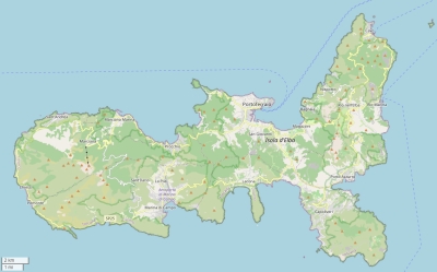
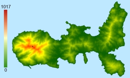
Topographic islandmap Elba © OpenStreetMap-auteurs, CC-BY-SA. Map Elba Elba views: 1402 Height map of Elba |


