Description island FaialThe inhabited fairly large island of Faial (local name Faial ) is part of (the island group) Azores and is located in the country of Portugal, Southern Europe. The distance to the mainland is about 1653.1 km. The surface-area of the island is 173.1 km2 and is therefore 0.456 x times greater than the island of Isle of Wight. The island lies in the Atlantic Ocean and the total coastal length is about 75 km and the dimensions of the island are approximately 21.2 km by 16.3 km (maximum width). The island is West-northwest - East-southeast oriented. The highest point is 1043 meter and is named Cabeço Gordo. The coordinates (latitude, longitude) of the island (center) for GPS are 38.58 (38°34'41.2356), -28.7 (-28°42'0.8676).The population is 15038 and the population density is thus on 86.90 inhabitants per square kilometer (compared Isle of Wight 364 inhabitants / km²). The capital of the island is Horta (located in the Southeast of the island). Other places on the island are: Salao (N), Ribeininha ( O), Praia do Norte (NW). The island is located in the West-northwest of the country Portugal. It is located in the administrative unit Autonomous Region Azores (local administrative level-name Região Autónoma), in the municipality Horta (local administrative level-name Concelho). Direct neighboring islands of Faial are (distance from central part island to central part of the neighboring islands): 1) Pico Located 6 km NorthNorthWest of the island. 2) São Jorge Located 30.2 km NorthEast of the island. 3) Graciosa Located 68.2 km NorthEast of the island. 4) Terceira Located 107.3 km North of the island. 5) Flores Located 219.3 km SouthSouthEast of the island. 6) Corvo Located 228.9 km SouthSouthEast of the island. 7) São Miguel Located 252.4 km NorthNorthWest of the island. 8) Ilhéu de Vila Franca Located 292.1 km NorthNorthWest of the island. 9) Santa Maria Located 346.8 km NorthNorthWest of the island. 10) Madeira Located 1205.8 km NorthNorthWest of the island. 11) Ilhas Desertas Located 1275.4 km NorthNorthWest of the island. 12) Ilhas Desertas Located 1277 km NorthNorthWest of the island. 13) Ilhas Desertas Located 1287.7 km NorthNorthWest of the island. 14) La Palma Located 1457.6 km NorthWest of the island. 15) El Hierro Located 1539.6 km NorthWest of the island. 16) La Gomera Located 1551.4 km NorthWest of the island. 17) Tenerife Located 1563.5 km NorthWest of the island. 18) Gran Canaria Located 1658.8 km NorthWest of the island. 19) Isla de Salvora Located 1709.5 km NorthNorthEast of the island. 20) Isla de Ons Located 1713.6 km NorthNorthEast of the island. 21) Islas Cies Located 1714.2 km NorthNorthEast of the island. 22) Isla de San Martiño o del Sur Located 1714.3 km NorthNorthEast of the island. 23) Alegranza Located 1718.7 km NorthNorthWest of the island. 24) Isla de Arosa Located 1721.4 km NorthNorthEast of the island. 25) Isla de La Toja Located 1723.3 km NorthNorthEast of the island. To return to the overview page of this island click on the following link: Overview island Faial |
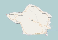
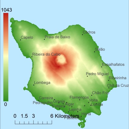
Topographic islandmap Faial © OpenStreetMap-auteurs, CC-BY-SA. Map Faial Faial views: 1985 Height map of Faial |


