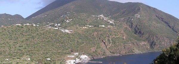
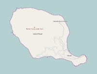
Description island FilicudiThe inhabited small island of Filicudi is part of (the island group) Aeolian Islands and is located in the country of Italy, Southern Europe. The distance to the mainland is about 98.2 km. The surface-area of the island is 9.3 km2 and is therefore 0.025 x times greater than the island of Isle of Wight. The island lies in the Tyrrhenian Sea and the total coastal length is about 15.6 km and the dimensions of the island are approximately 5.4 km by 3.1 km (maximum width). The island is West-northwest - East-southeast oriented. The highest point is 774 meter and is named Fossa Felci. The coordinates (latitude, longitude) of the island (center) for GPS are 38.57 (38°34'14.9772), 14.56 (14°33'47.3472).The population is 235 and the population density is thus on 25.00 inhabitants per square kilometer (compared Isle of Wight 364 inhabitants / km²). The capital of the island is Filicudi Porto (located in the South-southeast of the island). Other places on the island are: Pecorini Mare, Valdichiesa. The island is located in the South of the country Italy. It is located in the administrative unit Autonomous region Sicily (local administrative level-name regione), in the Province Messina (local administrative level-name Provincia ). Direct neighboring islands of Filicudi are (distance from central part island to central part of the neighboring islands): 1) Alicudi Located 15.4 km South of the island. 2) Salina Located 17.6 km North of the island. 3) Lipari Located 27.6 km NorthNorthWest of the island. 4) Vulcano Located 34 km NorthNorthWest of the island. 5) Panarea Located 40.8 km North of the island. 6) Sicily Located 45.3 km WestNorthWest of the island. 7) Stromboli Located 57.7 km NorthNorthEast of the island. 8) Ustica Located 117.5 km South of the island. 9) Isola di Levanzo Located 201.9 km SouthSouthWest of the island. 10) Isola di Favignana Located 203.3 km SouthSouthWest of the island. 11) Capri Located 218.5 km East of the island. 12) Isola di Marettimo Located 225.2 km SouthSouthWest of the island. 13) Ischia Located 240.2 km EastSouthEast of the island. 14) Procida Located 243.3 km East of the island. 15) Santo Stefano Located 261.6 km EastSouthEast of the island. 16) Ventotene Located 262.7 km EastSouthEast of the island. 17) Gozo Located 276 km West of the island. 18) Comino Located 282 km West of the island. 19) Malta Located 284.2 km West of the island. 20) Islands of St. Paul Located 287.4 km West of the island. 21) Di Ponza Located 288.6 km EastSouthEast of the island. 22) Gavi Located 292.3 km EastSouthEast of the island. 23) Isola Zannone Located 293 km EastSouthEast of the island. 24) Pantelleria Located 294.7 km SouthWest of the island. 25) Palmarola Located 297.4 km EastSouthEast of the island. For pedestrians, there is a ferry connection to the mainland also. Far as is known, there are good cycling opportunities on the island. The source material on the island consists of vulcanic. The land use on the island of Filicudi consists of nature 7.2 km2 (78%), and agriculture 2 km2 (22%), To return to the overview page of this island click on the following link: Overview island Filicudi |
|


