Description island GriendThe uninhabited very small island of Griend is part of (the island group) Wadden Islands and is located in the country of The Netherlands, Western Europe. The distance to the mainland is about 12.1 km. The surface-area of the island is 0.860 km2 and is therefore 0.002 x times greater than the island of Isle of Wight. The island lies in the Wadden Sea and the total coastal length is about 5.9 km and the length of the island is about km. The highest point is only 2 meter. The coordinates (latitude, longitude) of the island (center) for GPS are 53.25 (53°15'7.8048), 5.25 (5°15'11.4516).It is located in the administrative unit Province Friesland (local administrative level-name Provincie), in the Municipality Vlieland (local administrative level-name Gemeente). Direct neighboring islands of Griend are (distance from central part island to central part of the neighboring islands): 1) Richel Located 7 km SouthEast of the island. 2) Terschelling Located 10.8 km EastSouthEast of the island. 3) Vlieland Located 10.9 km SouthSouthEast of the island. 4) Texel Located 25.6 km SouthSouthWest of the island. 5) Ameland Located 31 km NorthEast of the island. 6) Noorderhaaks - De razende bol Located 46.8 km SouthWest of the island. 7) Het Rif Located 56.1 km NorthNorthEast of the island. 8) Engelsmanplaat Located 56.2 km NorthNorthEast of the island. 9) Schiermonnikoog Located 61.5 km NorthNorthEast of the island. 10) Zuidelijke Ballastplaat Located 62.1 km NorthNorthEast of the island. 11) Simonszand Located 80.7 km NorthNorthEast of the island. 12) Rottumerplaat Located 85 km NorthNorthEast of the island. 13) Rottumeroog Located 91.7 km NorthNorthEast of the island. 14) Zuiderduintjes Located 92.3 km NorthNorthEast of the island. 15) Pampus Located 98.8 km West of the island. 16) Borkum Located 99.3 km NorthNorthEast of the island. 17) Juist Located 115.5 km NorthNorthEast of the island. 18) Robinson Crusoë Located 117.3 km West of the island. 19) Markus Pos Located 117.7 km West of the island. 20) Geitekaai Located 118.5 km West of the island. 21) Meent Located 119.7 km West of the island. 22) Norderney Located 133.9 km NorthNorthEast of the island. 23) Baltrum Located 148.4 km NorthNorthEast of the island. 24) Langeoog Located 154.8 km NorthNorthEast of the island. 25) Middenplaat Located 165.4 km WestSouthWest of the island. The source material on the island consists of sand. The land use on the island of Griend consists of Sand - Rock 0.6 km2 (75%), wet nature 0.2 km2 (25%), To return to the overview page of this island click on the following link: Overview island Griend |
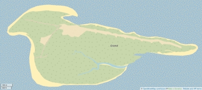
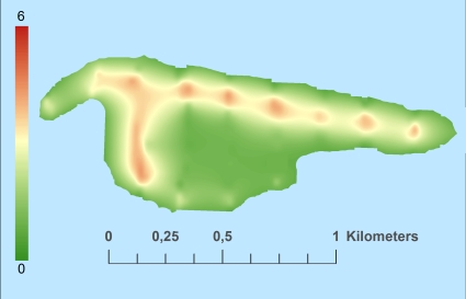
Topographic islandmap Griend © OpenStreetMap-auteurs, CC-BY-SA. Map Griend Griend views: 1062 Height map of Griend |


