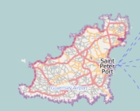
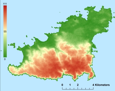
Description island GuernseyThe inhabited fairly large island of Guernsey is part of (the island group) Channel Islands and is located in the country of Guernsey-Jersey-Man, Western Europe. The distance to the mainland is about 44.3 km. The nearest (main) land is France and is not the country to which the island belongs. The surface-area of the island is 67.6 km2 and is therefore 0.178 x times greater than the island of Isle of Wight. The island lies in the English Channel and the total coastal length is about 45.7 km and the dimensions of the island are approximately 15 km by 8 km (maximum width). The island is Southwest - Northeast oriented. The highest point is 111 meter and is named Hautnez. The coordinates (latitude, longitude) of the island (center) for GPS are 49.46 (54°13'51.2436), -2.59 (-4°31'42.2904).The population is 65573 and the population density is thus on 836.00 inhabitants per square kilometer (compared Isle of Wight 364 inhabitants / km²). The capital of the island is Saint Peter Port (located in the East of the island). Other places on the island are: St Sampson, Castel. The island is located in the South of the country Guernsey-Jersey-Man. Direct neighboring islands of Guernsey are (distance from central part island to central part of the neighboring islands): 1) Lihou Located 0 km SouthSouthWest of the island. 2) Herm Located 3.9 km NorthNorthWest of the island. 3) Jethou Located 4.4 km NorthWest of the island. 4) Brecqhou Located 10.2 km North of the island. 5) Sark Located 11 km NorthNorthWest of the island. 6) Jersey Located 27.4 km NorthWest of the island. 7) Alderney Located 29.3 km NorthEast of the island. 8) Burhou Located 29.8 km NorthEast of the island. 9) Île de Bréhat Located 66.6 km WestSouthWest of the island. 10) Grande-Île Located 79.1 km NorthWest of the island. 11) Tombelaine Located 113 km NorthWest of the island. 12) Mont Saint-Michel Located 115.1 km NorthWest of the island. 13) Île de Batz Located 122.4 km SouthWest of the island. 14) Brownsea Island Located 136 km EastNorthEast of the island. 15) Isle of Wight Located 144.1 km EastNorthEast of the island. 16) Île de Béniguet Located 198.6 km SouthWest of the island. 17) Île d'Arz Located 202.4 km West of the island. 18) Île-aux-Moines Located 202.5 km West of the island. 19) Île-Molène Located 202.5 km SouthWest of the island. 20) Ouessant Located 203.2 km SouthSouthWest of the island. 21) Île Chevallier Located 205.9 km WestSouthWest of the island. 22) Groix Located 206.2 km WestSouthWest of the island. 23) Île du Loc'h Located 214.6 km WestSouthWest of the island. 24) Île de Sein Located 222.4 km SouthWest of the island. 25) Île-d'Houat Located 226.4 km West of the island. Note: The information described below is partly subject to change. The island is directly accessible from Western Europe by plane. An international airport is present on the island. The island is accessible by car (by means of ferry or bridge). The distance from Western-Europe (The Netherlands) is about 796 km. There is a ferry connection for cars to the mainland. For pedestrians, there is a ferry connection to the mainland also. Far as is known, there are good cycling opportunities on the island. To return to the overview page of this island click on the following link: Overview island Guernsey |
Topographic islandmap Guernsey © OpenStreetMap-auteurs, CC-BY-SA. Map Guernsey Guernsey views: 1758 Height map of Guernsey |


