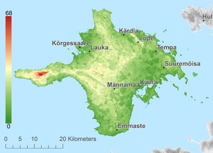
Description island HiiumaaThe inhabited large island of Hiiumaa is part of (the island group) West Estonian archipelago and is located in the country of Estonia, Northern Europe. The distance to the mainland is about 21.4 km. The nearest (main) land is Estland and is not the country to which the island belongs. The surface-area of the island is 1018.7 km2 and is therefore 2.7 x times greater than the island of Isle of Wight. The island lies in the Baltic Sea and the total coastal length is about 349.6 km and the dimensions of the island are approximately 60 km by 45 km (maximum width). The island is West - East oriented. The highest point is 68 meter and is named Tornimägi. The coordinates (latitude, longitude) of the island (center) for GPS are 58.88 (58°53'2.7312), 22.64 (22°38'10.5504).The population is 11087 and the population density is thus on 11.00 inhabitants per square kilometer (compared Isle of Wight 364 inhabitants / km²). The capital of the island is Kärdla (located in the North of the island). Other places on the island are: Emmaste (Z), Käina (ZO), Kõrgessaare (NW), Pühalepa (O). The island is located in the West of the country Estonia. It is located in the administrative unit Hiiu County (local administrative level-name Maakond), in the municipalities : 1) Emmaste 2) Hiiu 3) Käina 4) Pühalepa (local administrative level-name Vald). Direct neighboring islands of Hiiumaa are (distance from central part island to central part of the neighboring islands): 1) Saaremaa Located 5.1 km WestSouthWest of the island. 2) Vormsi Located 10.5 km NorthNorthEast of the island. 3) Muhu Located 17.5 km WestNorthWest of the island. 4) Osmussaar Located 42.1 km NorthEast of the island. 5) Vilsandi Located 48 km SouthWest of the island. 6) Abruka Located 56.8 km West of the island. 7) Suur-Pakri Located 66.3 km NorthEast of the island. 8) Väike-Pakri Located 69.6 km NorthEast of the island. 9) Kihnu Located 92.4 km NorthWest of the island. 10) Utö Located 100.4 km EastSouthEast of the island. 11) Ruhnu Located 102.7 km WestNorthWest of the island. 12) Naissaar Located 108.8 km NorthEast of the island. 13) Aegna Located 122.1 km NorthEast of the island. 14) Storlandet Located 123.5 km EastSouthEast of the island. 15) Korpo Located 125.1 km EastSouthEast of the island. 16) Prangli Located 135.7 km NorthNorthEast of the island. 17) Norrskata Located 137.2 km EastSouthEast of the island. 18) Houtskär Located 137.8 km EastSouthEast of the island. 19) Åland (Fasta) Located 155.7 km SouthEast of the island. 20) Keistiö Located 156.1 km EastSouthEast of the island. 21) Gotska Sandön Located 169.6 km SouthSouthWest of the island. 22) Suomenlinna Located 173 km NorthEast of the island. 23) Korkeasaari Located 175.6 km NorthEast of the island. 24) Möja Located 186.3 km SouthSouthEast of the island. 25) Runmarö Located 188.7 km SouthSouthEast of the island. The island is accessible by car (by means of ferry or bridge). The distance from Western-Europe (The Netherlands) is about 1738 km. There is a ferry connection for cars to the mainland. For pedestrians, there is a ferry connection to the mainland also. There are ferry connections with car to other (neighboring) island (s). There are also (seasonal) ferry connections for pedestrians (-cyclists) with other (neighboring) island(s). Far as is known, there are good cycling opportunities on the island. The land use on the island of Hiiumaa consists of wood 657.8 km2 (65%), nature 97.2 km2 (10%), wet nature 29.5 km2 (3%), and agriculture 215.8 km2 (21%), To return to the overview page of this island click on the following link: Overview island Hiiumaa |
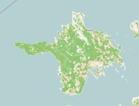
Topographic islandmap Hiiumaa © OpenStreetMap-auteurs, CC-BY-SA. Map Hiiumaa Hiiumaa views: 1580 Height map of Hiiumaa |


