Description island Île de BatzThe inhabited small island of Île de Batz is part of (the island group) and is located in the country of , Western Europe. The distance to the mainland is, quite close about 1.1 km. The surface-area of the island is 3.4 km2 and is therefore 0.009 x times greater than the island of Isle of Wight. The island lies in the and the total coastal length is about 12.9 km and the dimensions of the island are approximately 3.9 km by 1.00 km (maximum width). The island is West - East oriented. The coordinates (latitude, longitude) of the island (center) for GPS are 48.75 (48°4'28.3692), -4.01 (-4°0'51.8472).The population is 482 and the population density is thus on 151.00 inhabitants per square kilometer (compared Isle of Wight 364 inhabitants / km²). The capital of the island is Porz Kernok (located in the South of the island). Other places on the island are: Gwalez (N), Créac'h ar Bolloc'h (O), Porz Melloc (NO), Créac'h ar C'hastell(Z), Rupodou (Z), Porz Kernok (Z), Ar Ru (Z). The island is located in the of the country . It is located in the administrative unit (local administrative level-name ), in the (local administrative level-name ). Direct neighboring islands of Île de Batz are (distance from central part island to central part of the neighboring islands): 1) Île de Bréhat Located 72.6 km North of the island. 2) Île de Béniguet Located 73.3 km SouthWest of the island. 3) Île-Molène Located 77.8 km SouthSouthWest of the island. 4) Ouessant Located 79.6 km SouthSouthWest of the island. 5) Île Chevallier Located 97.4 km West of the island. 6) Île de Sein Located 98.6 km SouthWest of the island. 7) Île du Loc'h Located 114.1 km West of the island. 8) Guernsey Located 122.4 km NorthEast of the island. 9) Lihou Located 124.7 km NorthEast of the island. 10) Groix Located 125.7 km WestNorthWest of the island. 11) Jersey Located 136.3 km NorthNorthEast of the island. 12) Jethou Located 136.5 km NorthEast of the island. 13) Herm Located 137.7 km NorthEast of the island. 14) Sark Located 139 km NorthEast of the island. 15) Brecqhou Located 139.2 km NorthEast of the island. 16) Île-aux-Moines Located 151.9 km NorthWest of the island. 17) Île d'Arz Located 154.1 km NorthWest of the island. 18) Grande-Île Located 158.6 km North of the island. 19) Belle-Île-en-Mer Located 159.9 km WestNorthWest of the island. 20) Île-d'Houat Located 165.9 km WestNorthWest of the island. 21) Burhou Located 166.5 km NorthEast of the island. 22) Alderney Located 166.5 km NorthEast of the island. 23) Île Hoëdic Located 174.9 km WestNorthWest of the island. 24) Tombelaine Located 182.3 km North of the island. 25) Mont Saint-Michel Located 182.6 km North of the island. The source material on the island consists of rocky surface. The land use on the island of Île de Batz consists of nature 0.9 km2 (27%), wet nature 0 km2 (1%), and agriculture 1.5 km2 (45%), To return to the overview page of this island click on the following link: Overview island Île de Batz |
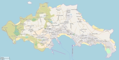
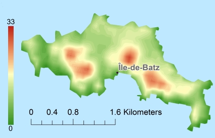
Topographic islandmap Île de Batz © OpenStreetMap-auteurs, CC-BY-SA. Map Île de Batz Île de Batz views: 293 Height map of Île de Batz |


