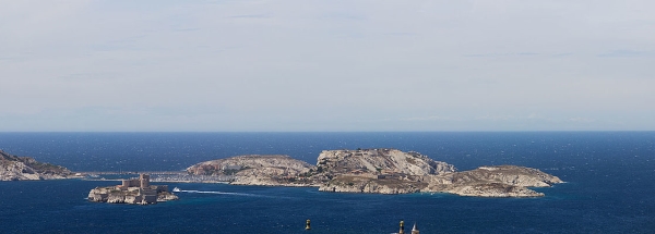
Description island Île RatonneauThe inhabited very small island of Île Ratonneau is part of (the island group) and is located in the country of , Western Europe. The distance to the mainland is, quite close about 1.8 km. The surface-area of the island is 0.980 km2 and is therefore 0.003 x times greater than the island of Isle of Wight. The island lies in the and the total coastal length is about 10.2 km and the dimensions of the island are approximately 2.7 km by 4.3 km (maximum width). The island is Southwest - Northeast oriented. The coordinates (latitude, longitude) of the island (center) for GPS are 43.28 (43°16'57.7776), 5.31 (5°18'30.1572).The population is 146 and the population density is thus on 76.00 inhabitants per square kilometer (compared Isle of Wight 364 inhabitants / km²). The capital of the island is Port du Frioul (located in the South of the island). Other places on the island are: Aantal inwoners samen Frioul-archipel: 146 inwoners. Fort du Brigandin (NW). The island is located in the of the country . It is located in the administrative unit (local administrative level-name ), in the (local administrative level-name ). Direct neighboring islands of Île Ratonneau are (distance from central part island to central part of the neighboring islands): 1) Île Pomègues Located 0.3 km WestNorthWest of the island. 2) Bendor eiland Located 38.5 km NorthNorthWest of the island. 3) Île des Embiez Located 43.3 km NorthNorthWest of the island. 4) Île de Porquerolles Located 75.1 km NorthNorthWest of the island. 5) Île de Port Cros Located 90.7 km NorthNorthWest of the island. 6) Île du Levant Located 95 km NorthNorthWest of the island. 7) Île Sainte-Marguerite Located 140.8 km NorthNorthEast of the island. 8) Île Saint-Honorat Located 140.9 km North of the island. 9) Medes Islands Located 217.6 km SouthWest of the island. 10) Corsica Located 282.1 km NorthNorthWest of the island. 11) Asinara Located 343.7 km NorthWest of the island. 12) Sardinia Located 350.1 km NorthWest of the island. 13) Capraia Located 364.5 km North of the island. 14) Menorca Located 368.1 km WestSouthWest of the island. 15) Château de Chillon Located 369.9 km EastNorthEast of the island. 16) Gorgona Located 370.3 km North of the island. 17) Isola San Giulio Located 370.7 km NorthEast of the island. 18) Palmaria Located 373.3 km NorthNorthEast of the island. 19) Isola del Tino Located 374.1 km NorthNorthEast of the island. 20) Isola del Tinetto Located 374.2 km NorthNorthEast of the island. 21) Illa den Colom Located 377.5 km WestSouthWest of the island. 22) Isola Bella Located 385.5 km NorthEast of the island. 23) Isola dei Pescatori Located 385.7 km NorthEast of the island. 24) Isola Madre Located 387.3 km NorthEast of the island. 25) Île Cavallo Located 387.3 km NorthNorthWest of the island. The source material on the island consists of rocky surface. The land use on the island of Île Ratonneau consists of nature 0.9 km2 (96%), To return to the overview page of this island click on the following link: Overview island Île Ratonneau |
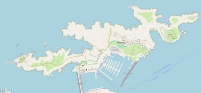
Topographic islandmap Île Ratonneau © OpenStreetMap-auteurs, CC-BY-SA. Map Île Ratonneau Île Ratonneau views: 244 |


