Description island KythiraThe inhabited large island of Kythira (local name Κύθηρα) is part of (the island group) Ionian Islands and is located in the country of Greece, Southern Europe. The distance to the mainland is about 13.6 km. The surface-area of the island is 276.6 km2 and is therefore 0.728 x times greater than the island of Isle of Wight. The island lies in the Aegean Sea and the total coastal length is about 111.2 km and the dimensions of the island are approximately 30 km by 17.5 km (maximum width). The island is North-northwest - South-southeast oriented. The highest point is 525 meter and is named Mermigkari. The coordinates (latitude, longitude) of the island (center) for GPS are 36.25 (36°14'53.3868), 22.98 (22°58'58.3248).The population is 3398 and the population density is thus on 299.40 inhabitants per square kilometer (compared Isle of Wight 364 inhabitants / km²). The capital of the island is Kýthira (located in the South of the island). Other places on the island are: Áno Livádi, Potamós, Agía Pelagía.Kálamos, Livádi. The island is located in the South of the country Greece. It is located in the administrative unit Region Attica (local administrative level-name Periféreia - περιοχή ), in the Regional unit Piraeus (local administrative level-name Nomos - Πειραιάς). Direct neighboring islands of Kythira are (distance from central part island to central part of the neighboring islands): 1) Monemvasia Located 34.1 km EastNorthEast of the island. 2) Crete Located 74.8 km NorthWest of the island. 3) Ydra Located 107.6 km EastNorthEast of the island. 4) Milos Located 118.1 km NorthNorthEast of the island. 5) Poros Located 131.2 km EastNorthEast of the island. 6) Kimolos Located 141 km NorthNorthEast of the island. 7) Aigina Located 150.5 km EastNorthEast of the island. 8) Serifos Located 152.1 km NorthEast of the island. 9) Sifnos Located 160.4 km NorthNorthEast of the island. 10) Kythnos Located 161.9 km NorthEast of the island. 11) Folegandros Located 162.2 km NorthNorthEast of the island. 12) Gavdos Located 167.4 km NorthWest of the island. 13) Salamina Located 170.9 km EastNorthEast of the island. 14) Kea Located 172.6 km NorthEast of the island. 15) Sikinos Located 180.8 km NorthNorthEast of the island. 16) Antiparos Located 189.8 km NorthNorthEast of the island. 17) Paros Located 198.1 km NorthNorthEast of the island. 18) Ios Located 199.3 km NorthNorthEast of the island. 19) Syros Located 200.8 km NorthEast of the island. 20) Santorini Located 202.5 km North of the island. 21) Euboea Located 215.8 km NorthEast of the island. 22) Naxos Located 219.6 km NorthNorthEast of the island. 23) Zakynthos Located 225.8 km SouthEast of the island. 24) Andros Located 227.2 km NorthEast of the island. 25) Tinos Located 228.4 km NorthEast of the island. Note: The information described below is partly subject to change. The island is directly accessible from Western Europe by plane. An international airport is present on the island. The island is accessible by car (by means of ferry or bridge). The distance from Western-Europe (The Netherlands) is about 2925 km. There is a ferry connection for cars to the mainland. For pedestrians, there is a ferry connection to the mainland also. There are ferry connections with car to other (neighboring) island (s). There are also (seasonal) ferry connections for pedestrians (-cyclists) with other (neighboring) island(s). Far as is known, there are good cycling opportunities on the island. To return to the overview page of this island click on the following link: Overview island Kythira |
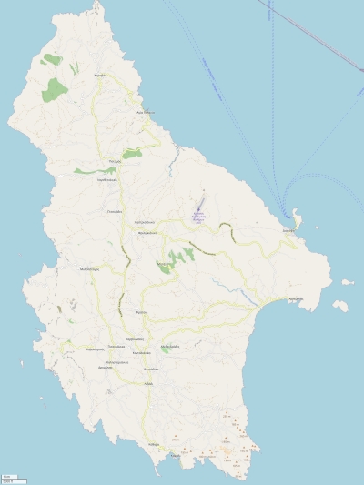
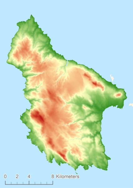
Topographic islandmap Kythira © OpenStreetMap-auteurs, CC-BY-SA. Map Kythira Kythira views: 1668 Height map of Kythira |


