Description island Mainland OrkneyThe inhabited large island of Mainland Orkney is part of (the island group) Orkney Islands and is located in the country of Great Britain , Western Europe. The distance to the mainland is about 27.8 km. The surface-area of the island is 493.6 km2 and is therefore 1.3 x times greater than the island of Isle of Wight. The island lies in the North Sea and the total coastal length is about 297.4 km and the dimensions of the island are approximately 42.5 km by 22.7 km (maximum width). The island is Northwest - Southeast oriented. The highest point is 271 meter and is named Mid Hill. The coordinates (latitude, longitude) of the island (center) for GPS are 59 (58° 59' 45.672), -3.15 (3° 8' 51.324).The population is 15315 and the population density is thus on 29.27 inhabitants per square kilometer (compared Isle of Wight 364 inhabitants / km²). The capital of the island is Kirkwall (located in the North-northeast of the island). Other places on the island are: Stromness (ZW), Birsay (NW). The island is located in the North of the country Great Britain . It is located in the administrative unit Council area Orkney Islands (local administrative level-name council area), in the Ward West Mainland (local administrative level-name Ward). Direct neighboring islands of Mainland Orkney are (distance from central part island to central part of the neighboring islands): 1) Inner Holm Located 0.1 km WestSouthWest of the island. 2) Holm of Grimbister Located 0.3 km NorthEast of the island. 3) Graemsay Located 0.9 km West of the island. 4) Gairsay Located 1.1 km NorthNorthEast of the island. 5) Rousay Located 1.4 km NorthEast of the island. 6) Shapinsay Located 1.7 km East of the island. 7) Burray Located 2.1 km WestNorthWest of the island. 8) Wyre Located 2.2 km NorthNorthEast of the island. 9) Hoy Located 2.6 km WestSouthWest of the island. 10) South Ronaldsay Located 5.4 km SouthWest of the island. 11) Fara Located 6.1 km West of the island. 12) Egilsay Located 7.2 km NorthNorthEast of the island. 13) Flotta Located 8.2 km WestNorthWest of the island. 14) Auskerry Located 9.7 km NorthEast of the island. 15) Stronsay Located 11.5 km NorthEast of the island. 16) South Walls Located 11.9 km West of the island. 17) Eday Located 14.4 km NorthNorthEast of the island. 18) Westray Located 15.9 km NorthEast of the island. 19) Sanday Located 21.7 km NorthEast of the island. 20) Island of Stroma Located 24.2 km WestSouthWest of the island. 21) Papa Westray Located 24.3 km EastNorthEast of the island. 22) North Ronaldsay Located 44 km NorthEast of the island. 23) Fair Isle Located 85 km NorthEast of the island. 24) Foula Located 123.7 km EastNorthEast of the island. 25) Mainland Shetland Located 126.4 km NorthEast of the island. The island is accessible by car (by means of ferry or bridge). The distance from Western-Europe (The Netherlands) is about 1201 km. There is a ferry connection for cars to the mainland. For pedestrians, there is a ferry connection to the mainland also. There are ferry connections with car to other (neighboring) island (s). There are also (seasonal) ferry connections for pedestrians (-cyclists) with other (neighboring) island(s). Far as is known, there are good cycling opportunities on the island. The source material on the island consists of rocky surface. The land use on the island of Mainland Orkney consists of nature 90.4 km2 (18%), wet nature 49.7 km2 (10%), and agriculture 339.3 km2 (69%), To return to the overview page of this island click on the following link: Overview island Mainland Orkney |
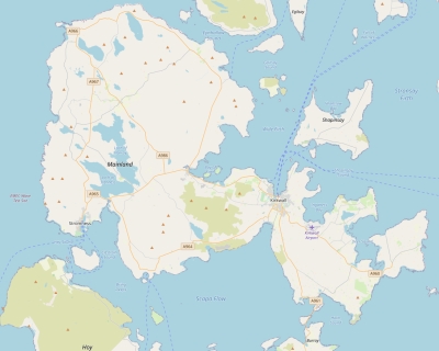
Topographic islandmap Mainland Orkney © OpenStreetMap-auteurs, CC-BY-SA. Map Mainland Orkney Mainland Orkney views: 840 |


