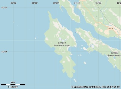
Description island МантсинсаариThe inhabited small island of Мантсинсаари is part of (the island group) and is located in the country of , Eastern Europe. The island is situated in a lake. The distance to the mainland is, quite close about 0.3 km. The surface-area of the island is 43.3 km2 and is therefore 0.114 x times greater than the island of Isle of Wight. The island lies in the and the total coastal length is about 49.5 km and the dimensions of the island are approximately 15 km by 6 km (maximum width). The island is North-northwest - South-southeast oriented. The coordinates (latitude, longitude) of the island (center) for GPS are 61.35 (61°20'51.540), 31.61 (31°36'18.2520).The population is 1 and the population density is thus on 0.02 inhabitants per square kilometer (compared Isle of Wight 364 inhabitants / km²). Other places on the island are: Пелтонин (Peltoinen), Оритселен (Oritselän), Тёмпейсен (Työmpäisen) . The island is located in the of the country . It is located in the administrative unit (local administrative level-name ), in the (local administrative level-name ). Direct neighboring islands of Mantsinsaari are (distance from central part island to central part of the neighboring islands): 1) Valaam Located 26.9 km South of the island. 2) Konevets Located 69.6 km SouthWest of the island. 3) Kotlin Located 173.3 km SouthWest of the island. 4) Beryozovye Islands Located 193.2 km SouthWest of the island. 5) Kizhi Located 204 km NorthNorthEast of the island. 6) Seskar Located 225.3 km SouthWest of the island. 7) Moshchny Located 248.5 km SouthWest of the island. 8) Hogland Located 285.6 km SouthSouthWest of the island. 9) Bolshoy Tyuters Located 289 km SouthSouthWest of the island. 10) Enonsaari Located 320.9 km South of the island. 11) Emäsalo Located 341.6 km SouthSouthWest of the island. 12) Korkeasaari Located 379.9 km SouthSouthWest of the island. 13) Suomenlinna Located 381.2 km SouthSouthWest of the island. 14) Piirissaare Located 396.4 km SouthWest of the island. 15) Prangli Located 405.9 km SouthSouthWest of the island. 16) Aegna Located 420 km SouthSouthWest of the island. 17) Kolpina Located 421.6 km WestSouthWest of the island. 18) Naissaar Located 432.2 km SouthSouthWest of the island. 19) Kiy Located 432.9 km NorthEast of the island. 20) Solovetsky Islands Located 445.1 km EastNorthEast of the island. 21) Stolobny Located 457.9 km West of the island. 22) Väike-Pakri Located 472 km SouthSouthWest of the island. 23) Suur-Pakri Located 475.1 km SouthSouthWest of the island. 24) Osmussaar Located 503.8 km SouthSouthWest of the island. 25) Hailuoto Located 519.1 km SouthEast of the island. The source material on the island consists of rocky surface. The land use on the island of Mantsinsaari consists of To return to the overview page of this island click on the following link: Overview island Мантсинсаари |
Topographic islandmap Мантсинсаари © OpenStreetMap-auteurs, CC-BY-SA. Map Mantsinsaari Мантсинсаари views: 216 |


