Description island NorderneyThe inhabited small island of Norderney is part of (the island group) Wadden Islands and is located in the country of Germany, Western Europe. The distance to the mainland is, quite close about 2.9 km. The surface-area of the island is 25.9 km2 and is therefore 0.068 x times greater than the island of Isle of Wight. The island lies in the Wadden Sea and the total coastal length is about 34.9 km and the dimensions of the island are approximately 14 km by 2 km (maximum width). The island is West - East oriented. The highest point is 24.4 meter and is named Weißen Düne. The coordinates (latitude, longitude) of the island (center) for GPS are 53.71 (53°42'49.4136), 7.24 (7°14'16.0296).The population is 6032 and the population density is thus on 229.00 inhabitants per square kilometer (compared Isle of Wight 364 inhabitants / km²). The capital of the island is norderney (located in the West of the island). Other places on the island are: Nordhelm. The island is located in the Northwest of the country Germany. It is located in the administrative unit State Lower Saxony (local administrative level-name Land), in the District Aurich (local administrative level-name Landkreis). Direct neighboring islands of Norderney are (distance from central part island to central part of the neighboring islands): 1) Baltrum Located 0.9 km NorthNorthEast of the island. 2) Juist Located 3.6 km SouthWest of the island. 3) Langeoog Located 7.7 km North of the island. 4) Spiekeroog Located 21.5 km NorthNorthEast of the island. 5) Borkum Located 24.9 km SouthSouthWest of the island. 6) Wangerooge Located 33.6 km NorthNorthEast of the island. 7) Rottumeroog Located 39.2 km SouthSouthWest of the island. 8) Zuiderduintjes Located 41.2 km SouthSouthWest of the island. 9) Rottumerplaat Located 45.6 km SouthSouthWest of the island. 10) Simonszand Located 51.6 km SouthSouthWest of the island. 11) Schiermonnikoog Located 55.1 km SouthSouthWest of the island. 12) Heligoland Located 61.4 km NorthEast of the island. 13) Heligoland-Düne Located 62.9 km NorthEast of the island. 14) Zuidelijke Ballastplaat Located 72.1 km SouthSouthWest of the island. 15) Het Rif Located 76.3 km SouthSouthWest of the island. 16) Engelsmanplaat Located 76.4 km SouthSouthWest of the island. 17) Ameland Located 81.6 km SouthSouthWest of the island. 18) Terschelling Located 108.9 km SouthSouthWest of the island. 19) Amrum Located 118.9 km EastNorthEast of the island. 20) Pellworm Located 119.2 km NorthEast of the island. 21) Föhr Located 128.7 km EastNorthEast of the island. 22) Sylt Located 128.9 km EastNorthEast of the island. 23) Griend Located 133.9 km SouthSouthWest of the island. 24) Richel Located 138.9 km SouthSouthWest of the island. 25) Vlieland Located 142.4 km SouthSouthWest of the island. The island is accessible by car (by means of ferry or bridge). The distance from Western-Europe (The Netherlands) is about 303 km. There is a ferry connection for cars to the mainland. For pedestrians, there is a ferry connection to the mainland also. Far as is known, there are good cycling opportunities on the island. The source material on the island consists of sand. The land use on the island of Norderney consists of Sand - Rock 7.4 km2 (29%), wood 0.3 km2 (1%), nature 7.4 km2 (28%), wet nature 5.8 km2 (22%), and agriculture 2.7 km2 (10%), To return to the overview page of this island click on the following link: Overview island Norderney |
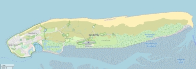
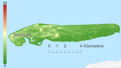
Topographic islandmap Norderney © OpenStreetMap-auteurs, CC-BY-SA. Map Norderney Norderney views: 859 Height map of Norderney |


