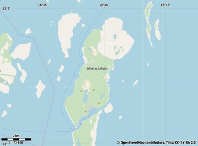
Description island Norra UlvönThe inhabited small island of Norra Ulvön is part of (the island group) and is located in the country of , Northern Europe. The distance to the mainland is about 5.1 km. The surface-area of the island is 16 km2 and is therefore 0.042 x times greater than the island of Isle of Wight. The island lies in the and the total coastal length is about 24.5 km and the dimensions of the island are approximately 8.1 km by 3.2 km (maximum width). The island is North - South oriented. The coordinates (latitude, longitude) of the island (center) for GPS are 63.05 (63°2'52.1952), 18.66 (18°39'32.0148).The population is 0 and the population density is thus on 0.00 inhabitants per square kilometer (compared Isle of Wight 364 inhabitants / km²). The capital of the island is Ulvöhamn (located in the South of the island). The island is located in the of the country . It is located in the administrative unit (local administrative level-name ), in the (local administrative level-name ). Direct neighboring islands of Norra Ulvön are (distance from central part island to central part of the neighboring islands): 1) Södra Ulvön Located 0.1 km WestNorthWest of the island. 2) Hemsön Located 37.7 km SouthWest of the island. 3) Alnön Located 84.5 km SouthWest of the island. 4) Replot Located 122.2 km NorthNorthEast of the island. 5) Holmön Located 127.1 km NorthNorthEast of the island. 6) Björkö Located 131 km NorthNorthEast of the island. 7) Frösön Located 202 km South of the island. 8) Gräsö Located 279.1 km West of the island. 9) Åland (Fasta) Located 295.1 km WestNorthWest of the island. 10) Singö Located 310.6 km West of the island. 11) Sollerön Located 312.3 km SouthWest of the island. 12) Keistiö Located 324.1 km WestNorthWest of the island. 13) Houtskär Located 340.7 km WestNorthWest of the island. 14) Norrskata Located 342.6 km WestNorthWest of the island. 15) Korpo Located 351.4 km WestNorthWest of the island. 16) Storlandet Located 353.1 km WestNorthWest of the island. 17) Rånön Located 354.4 km EastNorthEast of the island. 18) Hailuoto Located 358.6 km NorthEast of the island. 19) Seskarö Located 379.5 km NorthEast of the island. 20) Utö Located 387.7 km WestNorthWest of the island. 21) Kataja Located 393.1 km NorthEast of the island. 22) Möja Located 397.3 km West of the island. 23) Grinda Located 400 km West of the island. 24) Leka Located 404.4 km SouthEast of the island. 25) Runmarö Located 413.1 km West of the island. The source material on the island consists of rocky surface. The land use on the island of Norra Ulvön consists of wood 14.7 km2 (92%), nature 0.7 km2 (5%), and agriculture 0.4 km2 (2%), To return to the overview page of this island click on the following link: Overview island Norra Ulvön |
Topographic islandmap Norra Ulvön © OpenStreetMap-auteurs, CC-BY-SA. Map Norra Ulvön Norra Ulvön views: 208 |


