Description island ÖlandThe inhabited large island of Öland is located in the country of Sweden, Northern Europe. The distance to the mainland is about 3.1 km. The surface-area of the island is 1347.5 km2 and is therefore 3.5 x times greater than the island of Isle of Wight. The island lies in the Baltic Sea and the total coastal length is about 423.9 km and the dimensions of the island are approximately 137 km by 16 km (maximum width). The island is North-northeast - South-southwest oriented. The highest point is 55 meter and is named Högsrum. The coordinates (latitude, longitude) of the island (center) for GPS are 56.73 (56°43'31.5192), 16.66 (16°39'37.2924).The population is 24697 and the population density is thus on 18.30 inhabitants per square kilometer (compared Isle of Wight 364 inhabitants / km²). The capital of the island is Färjestaden (located in the West-southwest of the island). Other places on the island are: Borgholm (W), Byxelkrok (N), Böda (N), Löttorp (N), Sandvik (NW), Färjestaden (ZW), Mörbylånga (ZW), Mellby (Z). The island is located in the South of the country Sweden. It is located in the administrative unit County Kalmar (local administrative level-name Län), in the municipalities : 1) Borgholm 2) Mörbylånga (local administrative level-name Kommun). Direct neighboring islands of Öland are (distance from central part island to central part of the neighboring islands): 1) Utlängan Located 40.9 km SouthSouthWest of the island. 2) Sturkö Located 42.1 km SouthSouthWest of the island. 3) Aspö Located 52.3 km South of the island. 4) Gotland Located 57 km North of the island. 5) Hanö Located 98 km SouthSouthWest of the island. 6) Ivö Located 122 km South of the island. 7) Fårö Located 129.5 km NorthNorthEast of the island. 8) Bornholm Located 141.3 km SouthWest of the island. 9) Gotska Sandön Located 165.3 km NorthEast of the island. 10) Bolmsö Located 165.4 km SouthSouthEast of the island. 11) Visingsö Located 176 km SouthSouthEast of the island. 12) Utö Located 183.2 km EastNorthEast of the island. 13) Ornö Located 197.4 km EastNorthEast of the island. 14) Nämdö Located 220.9 km EastNorthEast of the island. 15) Runmarö Located 230.4 km EastNorthEast of the island. 16) Ven Located 230.9 km South of the island. 17) Hallands Väderö Located 233.5 km South of the island. 18) Saltholm Located 233.8 km SouthSouthWest of the island. 19) Seeland Located 235.1 km South of the island. 20) Amager Located 240.6 km SouthSouthWest of the island. 21) Grinda Located 242.5 km EastNorthEast of the island. 22) Torsö Located 245.9 km SouthEast of the island. 23) Möja Located 249.4 km EastNorthEast of the island. 24) Rügen Located 250.1 km SouthWest of the island. 25) Wolin Located 263.1 km WestSouthWest of the island. The island is accessible by car (by means of ferry or bridge). The distance from Western-Europe (The Netherlands) is about 1186 km. There is a ferry connection for cars to the mainland. For pedestrians, there is a ferry connection to the mainland also. Far as is known, there are good cycling opportunities on the island. The land use on the island of Öland consists of Sand - Rock 12.1 km2 (1%), wood 233.3 km2 (17%), nature 220.9 km2 (16%), and agriculture 834.4 km2 (62%), To return to the overview page of this island click on the following link: Overview island Öland |
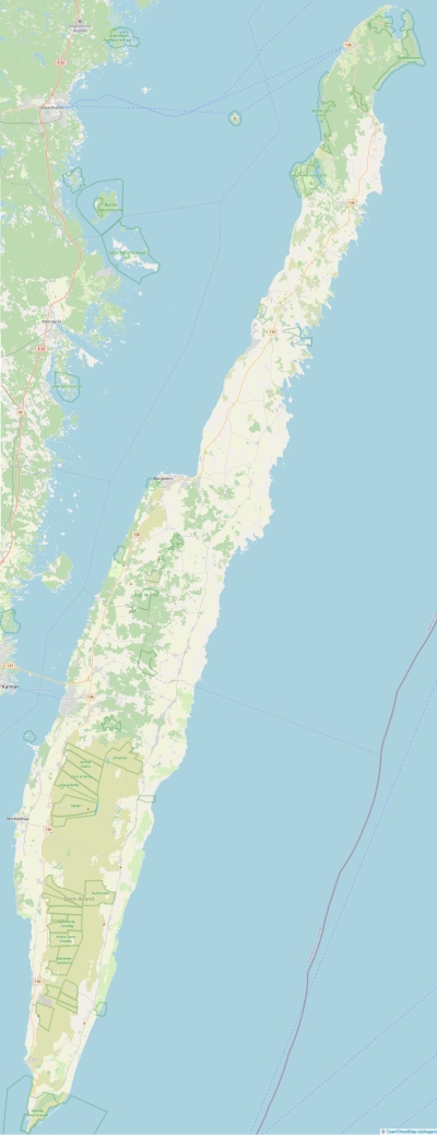
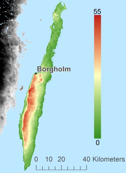
Topographic islandmap Öland © OpenStreetMap-auteurs, CC-BY-SA. Map Öland Öland views: 1442 Height map of Öland |


