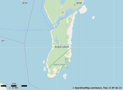
Description island Södra UlvönThe inhabited small island of Södra Ulvön is part of (the island group) and is located in the country of , Northern Europe. The distance to the mainland is about 3.2 km. The surface-area of the island is 6.8 km2 and is therefore 0.018 x times greater than the island of Isle of Wight. The island lies in the and the total coastal length is about 17 km and the dimensions of the island are approximately 5.5 km by 2 km (maximum width). The island is North - South oriented. The coordinates (latitude, longitude) of the island (center) for GPS are 63 (62°5'58.2432), 18.64 (18°38'16.2816).The population is 0 and the population density is thus on 0.00 inhabitants per square kilometer (compared Isle of Wight 364 inhabitants / km²). The capital of the island is Marviksgrunnan (located in the Southwest of the island). Other places on the island are: Marviksgrunnan. The island is located in the of the country . It is located in the administrative unit (local administrative level-name ), in the (local administrative level-name ). Direct neighboring islands of Södra Ulvön are (distance from central part island to central part of the neighboring islands): 1) Norra Ulvön Located 0.1 km EastSouthEast of the island. 2) Hemsön Located 34.4 km SouthWest of the island. 3) Alnön Located 81.4 km SouthWest of the island. 4) Replot Located 125.5 km NorthNorthEast of the island. 5) Holmön Located 131.8 km NorthEast of the island. 6) Björkö Located 134.4 km NorthNorthEast of the island. 7) Frösön Located 202.8 km South of the island. 8) Gräsö Located 275 km West of the island. 9) Åland (Fasta) Located 291.1 km WestNorthWest of the island. 10) Singö Located 306.5 km West of the island. 11) Sollerön Located 309.1 km SouthWest of the island. 12) Keistiö Located 320.5 km WestNorthWest of the island. 13) Houtskär Located 337.1 km WestNorthWest of the island. 14) Norrskata Located 339.1 km WestNorthWest of the island. 15) Korpo Located 347.8 km WestNorthWest of the island. 16) Storlandet Located 349.6 km WestNorthWest of the island. 17) Rånön Located 360.4 km EastNorthEast of the island. 18) Hailuoto Located 363.6 km NorthEast of the island. 19) Utö Located 384 km WestNorthWest of the island. 20) Seskarö Located 385.3 km NorthEast of the island. 21) Möja Located 393.2 km West of the island. 22) Grinda Located 395.9 km West of the island. 23) Kataja Located 398.8 km NorthEast of the island. 24) Leka Located 407.6 km SouthEast of the island. 25) Runmarö Located 409 km West of the island. The source material on the island consists of rocky surface. The land use on the island of Södra Ulvön consists of Sand - Rock 0.5 km2 (7%), wood 6.1 km2 (91%), To return to the overview page of this island click on the following link: Overview island Södra Ulvön |
Topographic islandmap Södra Ulvön © OpenStreetMap-auteurs, CC-BY-SA. Map Södra Ulvön Södra Ulvön views: 458 |


