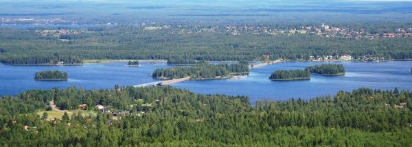
Description island SollerönThe inhabited small island of Sollerön is part of (the island group) and is located in the country of , Northern Europe. The island is situated in a lake. The distance to the mainland is, quite close about 0 km. The surface-area of the island is 22.6 km2 and is therefore 0.059 x times greater than the island of Isle of Wight. The island lies in the and the total coastal length is about 26.9 km and the dimensions of the island are approximately 6.4 km by 6.1 km (maximum width). The island is South - North oriented. The coordinates (latitude, longitude) of the island (center) for GPS are 60.91 (60°54'47.2716), 14.61 (14°36'42.8976).The population is 1215 and the population density is thus on 53.80 inhabitants per square kilometer (compared Isle of Wight 364 inhabitants / km²). Other places on the island are: Sollerön. The island is located in the of the country . It is located in the administrative unit (local administrative level-name ), in the (local administrative level-name ). Direct neighboring islands of Sollerön are (distance from central part island to central part of the neighboring islands): 1) Gräsö Located 206.5 km North of the island. 2) Alnön Located 217 km NorthEast of the island. 3) Torsö Located 230.8 km West of the island. 4) Singö Located 234 km NorthNorthWest of the island. 5) Frösön Located 247.8 km East of the island. 6) Kållandsö Located 255.9 km WestSouthWest of the island. 7) Hemsön Located 264 km NorthEast of the island. 8) Grinda Located 271 km NorthWest of the island. 9) Kirkøy Located 279.8 km SouthWest of the island. 10) Åland (Fasta) Located 280.2 km North of the island. 11) Möja Located 283.7 km NorthNorthWest of the island. 12) Runmarö Located 288.8 km NorthWest of the island. 13) Ornö Located 288.8 km NorthWest of the island. 14) Nämdö Located 292.2 km NorthWest of the island. 15) Utö Located 294.3 km NorthWest of the island. 16) Syd-Koster Located 296.9 km SouthWest of the island. 17) Nord-Koster Located 297 km SouthWest of the island. 18) Södra Ulvön Located 309.1 km NorthEast of the island. 19) Visingsö Located 309.8 km West of the island. 20) Norra Ulvön Located 312.3 km NorthEast of the island. 21) Orust Located 329.7 km WestSouthWest of the island. 22) Tjörn Located 351.5 km WestSouthWest of the island. 23) Keistiö Located 366.7 km North of the island. 24) Houtskär Located 370.4 km North of the island. 25) Koön Located 372.9 km WestSouthWest of the island. The source material on the island consists of rocky surface. The land use on the island of Sollerön consists of wood 10.5 km2 (47%), nature 0.6 km2 (3%), wet nature 0.4 km2 (2%), and agriculture 7.7 km2 (34%), To return to the overview page of this island click on the following link: Overview island Sollerön |
|


