Description island StreymoyThe inhabited large island of Streymoy is part of (the island group) Faroe Islands and is located in the country of Faroe Islands, Northern Europe. The distance to the mainland is about 380 km. The nearest (main) land is Great Britain and is not the country to which the island belongs. The surface-area of the island is 377.6 km2 and is therefore 0.994 x times greater than the island of Isle of Wight. The island lies in the Atlantic Ocean and the total coastal length is about 161.9 km and the dimensions of the island are approximately 47 km by 12 km (maximum width). The island is North-northwest - South-southeast oriented. The highest point is 789 meter and is named Kopsenni: noordwesten van het eiland.. The coordinates (latitude, longitude) of the island (center) for GPS are 62.13 (62°7'37.2576), -7 (-7°0'13.1868).The population is 23420 and the population density is thus on 57.40 inhabitants per square kilometer (compared Isle of Wight 364 inhabitants / km²). The capital of the island is Tórshavn (located in the South-southeast of the island). Other places on the island are: Kollafjørður, Hoyvík, Argir, Vestmanna. The island is located in the Center of the country Faroe Islands. It is located in the administrative unit Streymoy Region (local administrative level-name sýsla), in the municipalities : 1) Streymoy 2) Hestur 3) Koltur 4) Nólsoy (local administrative level-name Kommuner). Direct neighboring islands of Streymoy are (distance from central part island to central part of the neighboring islands): 1) Eysturoy Located 0.3 km NorthNorthEast of the island. 2) Vágar Located 1 km South of the island. 3) Hestur Located 2.6 km WestSouthWest of the island. 4) Nólsoy Located 3 km North of the island. 5) Koltur Located 3.3 km SouthWest of the island. 6) Sandoy Located 5.5 km WestSouthWest of the island. 7) Kalsoy Located 14 km NorthEast of the island. 8) Borðoy Located 16.3 km NorthNorthEast of the island. 9) Mykines Located 16.6 km SouthSouthWest of the island. 10) Skúvoy Located 17.6 km WestSouthWest of the island. 11) Kunoy Located 18.2 km NorthEast of the island. 12) Viðoy Located 25.6 km NorthEast of the island. 13) Stóra Dímun Located 25.8 km West of the island. 14) Svínoy Located 28 km NorthEast of the island. 15) Suðuroy Located 33.2 km WestSouthWest of the island. 16) Lítla Dímun Located 33.5 km West of the island. 17) Fugloy Located 35.3 km NorthEast of the island. 18) Mainland Shetland Located 318.1 km NorthNorthWest of the island. 19) Foula Located 320 km NorthWest of the island. 20) Papa Stour Located 322.8 km NorthNorthWest of the island. 21) Yell Located 329.2 km NorthNorthWest of the island. 22) Muckle Roe Located 332.6 km NorthNorthWest of the island. 23) Unst Located 334.3 km NorthNorthWest of the island. 24) Vaila Located 337.8 km NorthNorthWest of the island. 25) Fetlar Located 343.3 km NorthNorthWest of the island. The island is accessible by car (by means of ferry or bridge). The distance from Western-Europe (The Netherlands) is about 1725 km. There is a ferry connection for cars to the mainland. For pedestrians, there is a ferry connection to the mainland also. There are ferry connections with car to other (neighboring) island (s). There are also (seasonal) ferry connections for pedestrians (-cyclists) with other (neighboring) island(s). Far as is known, there are good cycling opportunities on the island. To return to the overview page of this island click on the following link: Overview island Streymoy |
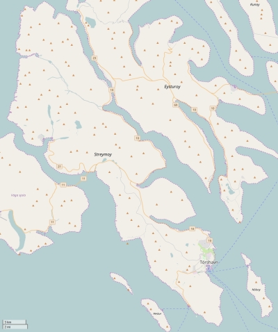
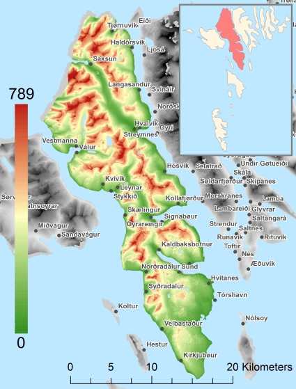
Topographic islandmap Streymoy © OpenStreetMap-auteurs, CC-BY-SA. Map Streymoy Streymoy views: 838 Height map of Streymoy |


