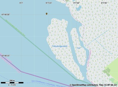
Description island TriboldingerbohlThe inhabited very small island of Triboldingerbohl is part of (the island group) and is located in the country of , Western Europe. The island is situated in a lake. The distance to the mainland is, quite close about 0 km. The surface-area of the island is 0.170 km2 and is therefore 0 x times greater than the island of Isle of Wight. The island lies in the and the total coastal length is about 1.8 km and the dimensions of the island are approximately 0.80 km by 0.30 km (maximum width). The island is West-northwest - East-southeast oriented. The coordinates (latitude, longitude) of the island (center) for GPS are 47.67 (47°40'19.4988), 9.12 (9°7'19.6644).The population is 0 and the population density is thus on 0.00 inhabitants per square kilometer (compared Isle of Wight 364 inhabitants / km²). The island is located in the of the country . It is located in the administrative unit (local administrative level-name ), in the (local administrative level-name ). Direct neighboring islands of Triboldingerbohl are (distance from central part island to central part of the neighboring islands): 1) Reichenau Located 2.4 km SouthSouthEast of the island. 2) Mainau Located 5.9 km NorthEast of the island. 3) Lindau Located 43.6 km NorthNorthWest of the island. 4) Lützelau Located 55.6 km WestSouthWest of the island. 5) Ufenau Located 56.3 km WestSouthWest of the island. 6) Insel Schwanau Located 81.1 km WestSouthWest of the island. 7) Rosen-Insel Located 166.2 km NorthNorthEast of the island. 8) Isola di Sant’Apollinare Located 173 km West of the island. 9) Isola di San Pancrazio Located 173.2 km West of the island. 10) Isola Comacina Located 189.3 km West of the island. 11) Isola Madre Located 200.3 km WestSouthWest of the island. 12) Isola dei Pescatori Located 201.7 km WestSouthWest of the island. 13) Isola Bella Located 202.2 km WestSouthWest of the island. 14) Isola San Giulio Located 215.3 km WestSouthWest of the island. 15) Château de Chillon Located 217.5 km SouthWest of the island. 16) Monte Isola Located 228.6 km WestNorthWest of the island. 17) Herreninsel Located 245.1 km North of the island. 18) Krautinsel Located 247.6 km North of the island. 19) Fraueninsel Located 248.3 km North of the island. 20) Isola di Garda Located 256.4 km WestNorthWest of the island. 21) Venice Located 347.7 km NorthWest of the island. 22) Isola di Murano Located 347.9 km NorthWest of the island. 23) La Giudecca Located 348.9 km NorthWest of the island. 24) Sant'Erasmo Located 350.6 km NorthWest of the island. 25) Pellestrina Located 351.1 km NorthWest of the island. The source material on the island consists of rocky surface. The land use on the island of Triboldingerbohl consists of wet nature 0.1 km2 (47%), To return to the overview page of this island click on the following link: Overview island Triboldingerbohl |
Topographic islandmap Triboldingerbohl © OpenStreetMap-auteurs, CC-BY-SA. Map Triboldingerbohl Triboldingerbohl views: 213 |


