|
|
|
Youtube Cyprus Video - Movie
For a detailed description of this island, see our info-island-page:Cyprus
|
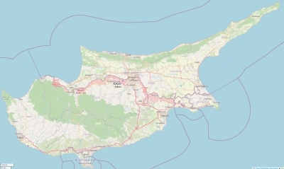
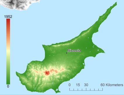
Physical characteristics - Location| Coordinates: | long: 33.31553 lat : 35.06496 | | Coordinates (gr,min,sec): WGS84 | long: 33°18'55.9116 lat : 35°3'53.8524 | | Surface area: | 9223 km2 (24.287 x Isle of Wight) | | Length coastline: | 905 km | | Average height: | 343 metre | | Length island: | 240 km | | Maximum width island (estimate): | 100 km | | Name : | Mount Olympus (1952 metre) | | Orientation island: | West-southwest - East-northeast |
Demographic data island| Habited: | Yes | | Number of inhabitants: | 1221549 | | Population density: | 132.00 inh/km2 | | Important places (direction): | Limassol (Z), Larnaca (ZZO), Paphos (W), Famagusta (OZO), Kyrenia |
|
Naming - Location| Local native name: | Kýpros | Neighboring islands
(Island hopping): | 1) Megisti - Kastellorizo 268.3 km WestNorthWest
2) Rodos 391.4 km WestNorthWest
3) Symi 428.9 km WestNorthWest
4) Chalki 439.2 km WestNorthWest
5) Karpathos 459.7 km West
6) Tilos 459.8 km WestNorthWest
7) Kasos 479.8 km West
8) Nisida Kvs 484.6 km WestNorthWest
9) Nisyros 486 km WestNorthWest
10) Kalymnos 513.3 km WestNorthWest
11) Leros 533.5 km WestNorthWest
12) Crete 542.5 km West
13) Astypalaia 548.9 km WestNorthWest
14) Samos 549.7 km WestNorthWest
15) Patmos 566.4 km WestNorthWest
16) Fournoi 583.6 km WestNorthWest
17) Amorgos 592.2 km WestNorthWest
18) Anafi 596.8 km WestNorthWest
19) Ikaria 602.7 km WestNorthWest
20) Santorini 629.8 km WestNorthWest
21) Hoog Koufonissi 633.3 km WestNorthWest
22) Laag Koufonissi 635 km WestNorthWest
23) Naxos 639.8 km WestNorthWest
24) Ios 645.3 km WestNorthWest
25) Chios 651.1 km WestNorthWest
| | Country: | Cyprus | | Location in Country: | Northeast | | Main place: | Nicosia | | Location Main place: | Center | | Sea: | Mediterranean Sea | | Distance to main land: | 68 km | | Nearest Country: | Turkey | | Type Rock outcrop: | rocky surface | | island-Type: | island in sea | | Remarks: | Politically divided into two parts |
Relief: Height Classes in percentages
Relief: Slope Classes in percentages
|
Weather at Cyprus
| The weather type in Tséri | few clouds |  | | Current temperature: | 20 degrees Celcius
| | Precipitation last 3 hours: | No precipitation | | Wind: | 2.06 meter per second (Wind force - bft 2)
| | Winddirection: | West | | Atmospheric pressure: | 1018 mb
| | Humidity: | 49 %
| | Daylength at 21 November 2024: | 10 hour and 11 minutes | | Sunrise: | 05:27 Europe/Amsterdam | | Sunset: | 15:38 Europe/Amsterdam |
Weather-page: Cyprus
The weather for the next few hours
Tséri - CY (longitude: 33.3155, latitude: 35.065)
Distance weather station to the center island (direction ZW): 1.2 km
13:00
18 degrees Celcius
1017 mbar
few clouds | 16:00
16 degrees Celcius
1018 mbar
clear sky | 19:00
16 degrees Celcius
1019 mbar
few clouds | 22:00
15 degrees Celcius
1019 mbar
broken clouds | 1:00
15 degrees Celcius
1019 mbar
scattered clouds |
Climate: Temperature and Precipitation
Transport on your island-holiday| Directly accessible from Western Europe (The Netherlands) by plane: | Yes | | International airport present : | Yes | | Distance from Western Europe (The Netherlands) (rough estimate): | 3788 km | | Ferry connection - Car - Car - with mainland: | No |
island-Island, island-Tourism - island-attractions
island accommodation: Hotel ,Holiday Home, Camping  Hotel Hotel |
Hotel at Cyprus booking.com
|
 Camping Camping | Not known
| | Holiday Home | | | Bed & Breakfast | | | accommodation-page | Cyprus
|
Social media - Multimedia
 Videos youtube Cyprus Videos youtube Cyprus
 Photos (Flickr) of the place Cyprus Photos (Flickr) of the place Cyprus
Bings maps Cyprus
Mapquest Cyprus
Loc.Alize.us Cyprus
Landuse Cyprus
| Forest |
1545.8 km2 |
|
| Nature |
2376.2 km2 |
|
| Agriculture |
4055.4 km2 |
|
| Wet nature |
7.9 km2 |
|
| Water |
19.2 km2 |
|
| Urban area |
747 km2 |
|
| Infrastructure |
33.8 km2 |
|
| Viticulture |
362.1 km2 |
|
| Rock outcrop |
75.8 km2 |
|
|
|
|
|
|
|


 Videos youtube Cyprus
 Photos (Flickr) of the place Cyprus


 Wikipedia:
  UNESCO:
  Camping