Hotels at Fuerteventura Hotels at Fuerteventura booking.com

previous island Gran Canaria island Fuerteventura next island Lanzarote

Booking.com

Youtube Fuerteventura Video - Movie


For a detailed description of this island, see our info-island-page:Fuerteventura

Physical characteristics - Location

Coordinates: long: -14.03678 lat : 28.40528
Coordinates (gr,min,sec): WGS84long: -14°2'12.4188 lat : 28°24'18.9972
Surface area: 1655.4 km2 (4.359 x Isle of Wight)
Length coastline: 291.2 km
Average height: 174 metre
Length island: 120 km
Maximum width island (estimate): 30 km
Name : Pico de la Zarza (812 metre)
Orientation island: Southwest - Northeast

Demographic data island

Habited: Yes
Number of inhabitants: 103167
Population density: 62.00 inh/km2
Important places (direction): La Oliva (N), Corrajelo (N)

Naming - Location

Local native name: Isla de Fuerteventura
Archipelago (island group): Canary Islands
Neighboring islands
(Island hopping):
1) Isla de Lobos 1.9 km NorthEast
2) Lanzarote 11 km North
3) Graciosa 61.1 km NorthNorthEast
4) Montaña Clara 68 km NorthNorthEast
5) Alegranza 77.9 km NorthNorthEast
6) Gran Canaria 84.6 km West
7) Tenerife 166.5 km WestNorthWest
8) La Gomera 254.4 km West
9) La Palma 323.3 km West
10) El Hierro 333.1 km West
11) Ilhas Desertas 471.4 km NorthNorthWest
12) Ilhas Desertas 479.7 km NorthNorthWest
13) Ilhas Desertas 491.7 km NorthNorthWest
14) Madeira 511.9 km NorthNorthWest
15) Perejil Island 1123.3 km NorthEast
16) Peñon de Vélez de la Gomera 1149.7 km NorthEast
17) Peñon de Alhucemas 1182.9 km NorthEast
18) Isla del Congreso 1292 km NorthEast
19) Isla de Alboran 1292.6 km NorthEast
20) Isla de Isabel II 1293.2 km NorthEast
21) Isla del Rey 1293.8 km NorthEast
22) Santa Maria 1373.1 km NorthWest
23) São Miguel 1441 km NorthWest
24) Ilhéu de Vila Franca 1456.8 km NorthWest
25) Isla de San Martiño o del Sur 1556.8 km NorthNorthEast
Country: Spain
Location in Country: Southwest
Name Comunidad autónoma: Autonomous Community Canary Islands
Name Provincia: Province Las Palmas
Main place: Puerto del Rosario
Location Main place: East-northeast
Sea: Atlantic Ocean
Distance to main land: 100 km
Nearest Country: Marocco
Type Rock outcrop: vulcanic
island-Type: island in sea
Remarks: Many sandy beaches and water sports possibilties

Municipalities

North - South West - East Name km2 Inhabitants
16La Oliva
      Hotels
      Photos
35621354
24Puerto del Rosario
      Hotels
      Photos
29035293
32Betancuria
      Hotels
      Photos
102715
45Antigua
      Hotels
      Photos
2529715
53Tuineje
      Hotels
      Photos
27513569
61Pájara
      Hotels
      Photos
38520283


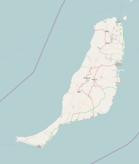
Topographic islandmap Fuerteventura

Fuerteventura map

© OpenStreetMap-auteurs, CC-BY-SA.
Map Fuerteventura

Fuerteventura views: 4097

5 starsaverage score: 5 from 2 votes.

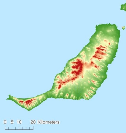
Height map of Fuerteventura

Fuerteventura Digital terrain model - DTM


Relief: Height Classes in percentages


Relief: Slope Classes in percentages


Weather at Fuerteventura

The weather type in Las Palmasclear skyweericoon
Current temperature: 20 degrees Celcius
Precipitation last 3 hours: No precipitation
Wind: 2.06 meter per second (Wind force - bft 2)
Winddirection: Northwest
Atmospheric pressure: 1019 mb
Humidity: 53 %
Daylength at 21 November 2024:10 hour and 37 minutes
Sunrise: 08:23 Europe/Amsterdam
Sunset: 19:00 Europe/Amsterdam
Weather-page: Fuerteventura

The weather for the next few hours

Las Palmas - ES (longitude: -14.0368, latitude: 28.4053)
Distance weather station to the center island (direction NNW): not known
10:00
21 degrees Celcius
1019 mbar
light rainweericoon
13:00
23 degrees Celcius
1018 mbar
light rainweericoon
16:00
22 degrees Celcius
1018 mbar
light rainweericoon
19:00
21 degrees Celcius
1018 mbar
light rainweericoon
22:00
20 degrees Celcius
1018 mbar
light rainweericoon

Climate: Temperature and Precipitation


Transport on your island-holiday

Directly accessible from Western Europe (The Netherlands) by plane: Yes
International airport present : No
Accessible by car: No
Distance from Western Europe (The Netherlands) (rough estimate): 3946 km
Ferry connection - Car - Car - with mainland: Yes
Boat Connection - pedestrian - with mainland: Yes
Bicycle facilities: Yes

island-Island, island-Tourism - island-attractions

Wikipedia Fuerteventura ?> Wikipedia: Wikipedia Fuerteventura
Tourist information: Info Fuerteventura
Youtube: Youtube Fuerteventura


island accommodation: Hotel ,Holiday Home, Camping

Hotel at Fuerteventura ?> Hotel Hotel at Fuerteventura booking.com
Campings at Fuerteventura ?> Camping Not known
Holiday Home
Bed & Breakfast
accommodation-page Fuerteventura


Social media - Multimedia

Youtube Video FuerteventuraVideos youtube Fuerteventura
flickr pictures and images of FuerteventuraPhotos (Flickr) of the place Fuerteventura


Bings maps Fuerteventura
Mapquest Fuerteventura
Loc.Alize.us Fuerteventura

Landuse Fuerteventura

 Forest   2.2 km2 
 0% 
 Nature   1253.1 km2 
 76% 
 Agriculture   129.3 km2 
 8% 
 Wet nature   0 km2 
 0% 
 Water   4.9 km2 
 0% 
 Urban area   78.3 km2 
 5% 
 Infrastructure   2.8 km2 
 0% 
 Viticulture   0 km2 
 0% 
 Rock outcrop   185 km2 
 11%