Hotels at La Gomera Hotels at La Gomera booking.com

previous island El Hierro island La Gomera next island Tenerife

Booking.com

Youtube La Gomera Video - Movie


For a detailed description of this island, see our info-island-page:La Gomera

Physical characteristics - Location

Coordinates: long: -17.23268 lat : 28.11737
Coordinates (gr,min,sec): WGS84long: -17°13'57.6516 lat : 28°0'42.2532
Surface area: 369.7 km2 (0.974 x Isle of Wight)
Length coastline: 95.5 km
Average height: 552 metre
Length island: 24 km
Maximum width island (estimate): 24 km
Name : Garajonay (1487 metre)
Orientation island: West-northwest - East-southeast

Demographic data island

Habited: Yes
Number of inhabitants: 23076
Population density: 62.41 inh/km2
Important places (direction): Valle Gran Rey (W)

Naming - Location

Local native name: Isla de La Gomera
Archipelago (island group): Canary Islands
Neighboring islands
(Island hopping):
1) Tenerife 27.5 km EastNorthEast
2) La Palma 57.7 km WestNorthWest
3) El Hierro 61.3 km WestSouthWest
4) Gran Canaria 125.1 km East
5) Fuerteventura 254.4 km East
6) Lanzarote 326.1 km EastNorthEast
7) Isla de Lobos 327.4 km EastNorthEast
8) Graciosa 368.1 km EastNorthEast
9) Montaña Clara 371.1 km EastNorthEast
10) Alegranza 375.7 km EastNorthEast
11) Ilhas Desertas 470.3 km North
12) Ilhas Desertas 477.8 km North
13) Ilhas Desertas 488.2 km North
14) Madeira 490.4 km North
15) Santa Maria 1206.7 km NorthWest
16) São Miguel 1286.3 km NorthNorthWest
17) Ilhéu de Vila Franca 1297.6 km NorthWest
18) Perejil Island 1398.7 km NorthEast
19) Peñon de Vélez de la Gomera 1441.3 km NorthEast
20) Terceira 1469.2 km NorthWest
21) Peñon de Alhucemas 1476.3 km NorthEast
22) São Jorge 1500.6 km NorthWest
23) Pico 1506.5 km NorthWest
24) Graciosa 1550.2 km NorthWest
25) Faial 1551.4 km NorthWest
Country: Spain
Location in Country: West-southwest
Name Comunidad autónoma: Autonomous Community Canary Islands
Name Provincia: Province Santa Cruz de Tenerife
Main place: San Sebastián de la Gomera
Location Main place: East
Sea: Atlantic Ocean
Distance to main land: 399 km
Nearest Country: Marocco
Type Rock outcrop: vulcanic
island-Type: island in sea
Remarks: accessible by boat from Tenerife. Known as walking island.

Municipalities

North - South West - East Name km2 Inhabitants
14Agulo
      Hotels
      Photos
261187
25Hermigua
      Hotels
      Photos
392178
32Vallehermoso
      Hotels
      Photos
1093147
41Valle Gran Rey
      Hotels
      Photos
335220
56San Sebastián de la Gomera
      Hotels
      Photos
1148744
63Alajeró
      Hotels
      Photos
492146


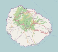
Topographic islandmap La Gomera

La Gomera map

© OpenStreetMap-auteurs, CC-BY-SA.
Map La Gomera

La Gomera views: 4872

3 starsaverage score: 3 from 5 votes.

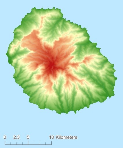
Height map of La Gomera

La Gomera Digital terrain model - DTM


Relief: Height Classes in percentages


Relief: Slope Classes in percentages


Weather at La Gomera

The weather type in Alajeróclear skyweericoon
Current temperature: 13 degrees Celcius
Precipitation last 3 hours: No precipitation
Wind: 2.06 meter per second (Wind force - bft 2)
Winddirection: West
Atmospheric pressure: 1015 mb
Humidity: 72 %
Daylength at 19 April 2024:12 hour and 57 minutes
Sunrise: 08:39 Europe/Amsterdam
Sunset: 21:36 Europe/Amsterdam
Weather-page: La Gomera

The weather for the next few hours

Alajeró - ES (longitude: -17.2327, latitude: 28.1174)
Distance weather station to the center island (direction N): 6.18 km

8:00
13 degrees Celcius
1016 mbar
clear skyweericoon
11:00
13 degrees Celcius
1018 mbar
scattered cloudsweericoon
14:00
14 degrees Celcius
1017 mbar
broken cloudsweericoon
17:00
14 degrees Celcius
1017 mbar
overcast cloudsweericoon
20:00
12 degrees Celcius
1018 mbar
broken cloudsweericoon

Climate: Temperature and Precipitation


Transport on your island-holiday

Directly accessible from Western Europe (The Netherlands) by plane: No
International airport present : No
Accessible by car: No
Distance from Western Europe (The Netherlands) (rough estimate): 4161 km
Ferry connection - Car - Car - with mainland: Yes
Boat Connection - pedestrian - with mainland: Yes
Bicycle facilities: Yes

island-Sights, island-Tourism - island-attractions

Wikipedia La Gomera ?> Wikipedia: Wikipedia La Gomera
Tourist information: Info La Gomera
Youtube: Youtube La Gomera
UNESCO La Gomera ?> UNESCO: Garajonay National Park


island accommodation: Hotel ,Holiday Home, Camping

Hotel at La Gomera ?> Hotel Hotel at La Gomera booking.com
Campings at La Gomera ?> Camping Not known
Holiday Home
Bed & Breakfast
accommodation-page La Gomera


Social media - Multimedia

Youtube Video La GomeraVideos youtube La Gomera
flickr pictures and images of La GomeraPhotos (Flickr) of the place La Gomera


Bings maps La Gomera
Mapquest La Gomera
Loc.Alize.us La Gomera

Landuse La Gomera

 Forest   83.4 km2 
 23% 
 Nature   207.1 km2 
 56% 
 Agriculture   58 km2 
 16% 
 Wet nature   0 km2 
 0% 
 Water   3.3 km2 
 1% 
 Urban area   3.5 km2 
 1% 
 Infrastructure   0.7 km2 
 0% 
 Viticulture   13.7 km2 
 4% 
 Rock outcrop   0 km2 
 0%