Hotels at Sicily Hotels at Sicily booking.com

previous island Isla del Congreso island Sicily next island Sardinia

Booking.com

Youtube Sicily Video - Movie


For a detailed description of this island, see our info-island-page:Sicily

Physical characteristics - Location

Coordinates: long: 14.15509 lat : 37.58778
Coordinates (gr,min,sec): WGS84long: 14°9'18.3348 lat : 37°35'16.0152
Surface area: 25437.6 km2 (66.985 x Isle of Wight)
Length coastline: 1346.1 km
Average height: 430 metre
Length island: 210 km
Maximum width island (estimate): 130 km
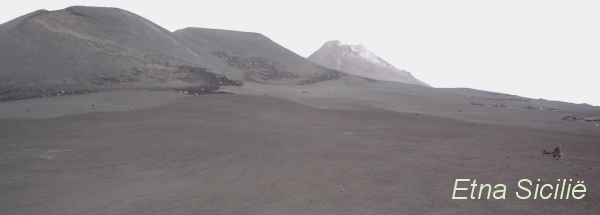
Name : Vulkaan Etna (3357 metre)
Orientation island: West-northwest - East-southeast

Demographic data island

Habited: Yes
Number of inhabitants: 4835884
Population density: 187.20 inh/km2
Important places (direction): Bagheria (N)
Cefalù (N)
Messina (NO)
Taormina (NO)
Acireale (O)
Catania (O)
Syracuse (ZO)
Noto (Z)
Ragusa (Z)
Modica (Z)
Vittoria (Z)
Gela (Z)
Agrigento (ZZW)
Mazara del Vallo (W)
Marsala (WNW)
Trapani (NW)
Palermo (NNW)

Caltanissetta (C)
Corleone (C)
Enna (C)

Naming - Location

Local native name: Sicilia
Neighboring islands
(Island hopping):
1) Isola di Favignana 7.8 km West
2) Isola di Levanzo 12.4 km West
3) Vulcano 20.3 km NorthNorthEast
4) Lipari 27.5 km North
5) Isola di Marettimo 32.5 km West
6) Salina 38.3 km North
7) Panarea 41.7 km NorthNorthWest
8) Filicudi 45.3 km NorthNorthWest
9) Alicudi 52.9 km NorthWest
10) Ustica 53.2 km NorthNorthWest
11) Stromboli 55.5 km North
12) Gozo 81 km SouthSouthWest
13) Comino 83.9 km SouthSouthWest
14) Malta 85.2 km SouthSouthWest
15) Islands of St. Paul 87.3 km SouthSouthWest
16) Pantelleria 100.4 km SouthWest
17) Linosa 161.5 km SouthSouthWest
18) Lampedusa 206.9 km SouthSouthWest
19) Lampione 217.9 km SouthSouthWest
20) Capri 265.7 km NorthNorthWest
21) Isole Cheradi 274 km NorthNorthEast
22) Ischia 278.4 km North
23) Sardinia 284 km WestNorthWest
24) Ventotene 284.4 km North
25) Santo Stefano 284.7 km North
Country: Italy
Location in Country: South-southeast
Name regione: Autonomous region Sicily
Name Provincia : Province Caltanissetta
Main place: Palermo
Location Main place: North-northwest
Sea: Mediterranean Sea
Distance to main land: 3.1 km
Nearest Country: Italy
Type Rock outcrop: vulcanic
island-Type: island in sea
Remarks: Very large island for a two-week holiday in the sun


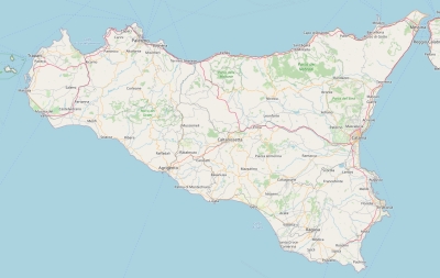
Topographic islandmap Sicily

Sicily map

© OpenStreetMap-auteurs, CC-BY-SA.
Map Sicilië

Sicily views: 3675

No score starsaverage score: No score from 0 votes.

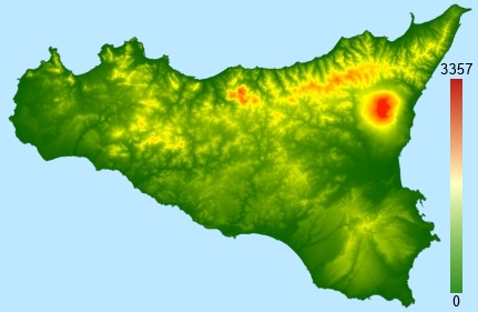
Height map of Sicily

Sicily Digital terrain model - DTM


Relief: Height Classes in percentages


Relief: Slope Classes in percentages


Weather at Sicily

The weather type in Villarosaovercast cloudsweericoon
Current temperature: 16 degrees Celcius
Precipitation last 3 hours: No precipitation
Wind: 2.44 meter per second (Wind force - bft 2)
Winddirection: Northwest
Atmospheric pressure: 1012 mb
Humidity: 83 %
Daylength at 21 November 2024:9 hour and 59 minutes
Sunrise: 06:49 Europe/Amsterdam
Sunset: 16:49 Europe/Amsterdam
Weather-page: Sicily

The weather for the next few hours

Villarosa - IT (longitude: 14.1551, latitude: 37.5878)
Distance weather station to the center island (direction W): 1.63 km

10:00
16 degrees Celcius
1012 mbar
overcast cloudsweericoon
13:00
16 degrees Celcius
1011 mbar
overcast cloudsweericoon
16:00
12 degrees Celcius
1013 mbar
overcast cloudsweericoon
19:00
11 degrees Celcius
1013 mbar
scattered cloudsweericoon
22:00
12 degrees Celcius
1012 mbar
scattered cloudsweericoon

Climate: Temperature and Precipitation


Transport on your island-holiday

Directly accessible from Western Europe (The Netherlands) by plane: Yes
International airport present : Yes
Accessible by car: Yes
Distance from Western Europe (The Netherlands) (rough estimate): 2285 km
Ferry connection - Car - Car - with mainland: Yes
Boat Connection - pedestrian - with mainland: Yes
Ferry - Car - connect with another island - Island hopping: Yes
Boat Connection - pedestrian - with another island: Yes
Bicycle facilities: Yes

island-Island, island-Tourism - island-attractions

Wikipedia Sicily ?> Wikipedia: Wikipedia Sicily
Tourist information: Info Sicily
Youtube: Youtube Sicily
UNESCO Sicilië ?> UNESCO: Late Baroque Towns of the Val di Noto (South-Eastern Sicily)


island accommodation: Hotel ,Holiday Home, Camping

Hotel at Sicilië ?> Hotel Hotel at Sicilië booking.com
Campings at Sicilië ?> Camping 1) Almoetia
2) Athena
3) Biscione
4) Camping Village Rais Gerbi
5) Camping Marina Caravan
6) Camping Villaggio Salica
7) Capo Passero
8) Capo Scalambri
9) Costa Ponente
10) Degli Ulivi
11) El-Bahira
12) Eraclea Minoa Village S.R.L.
13) Etna
14) Eurocamping Due Rocche
15) Helios Camping
16) Il Cicero
17) Il Maggiolino
18) Internazionale Nettuno
19) Jonio
20) Kamemi Camping Village
21) La Cabana Service
22) La Focetta Sicula
23) La Pineta
24) La Playa
25) La Timpa International Acireale
26) La Zagara
27) Lido Valderice
28) Lo Scoglio
29) Lu Baruni
30) Luminoso
31) Mokambo
32) Nausicaa
33) Nuovo Camping dello Stretto
34) Rinaura (Agritourist)
35) Riva Smeralda
36) Roccella Mare
37) Sabbiadoro
38) Sanfilippo
39) Scarabeo Camping
40) Sporting Club Village Camping
41) Sunseabeach
42) Valle dei Templi
43) Villaggio Marinello
Holiday Home
Bed & Breakfast
accommodation-page Sicily


Social media - Multimedia

Youtube Video SicilyVideos youtube Sicily
flickr pictures and images of SicilyPhotos (Flickr) of the place Sicily


Bings maps Sicily
Mapquest Sicily
Loc.Alize.us Sicily

Landuse Sicily

 Forest   2003 km2 
 8% 
 Nature   4433.8 km2 
 17% 
 Agriculture   12005.1 km2 
 47% 
 Wet nature   14.6 km2 
 0% 
 Water   106.7 km2 
 0% 
 Urban area   1148.8 km2 
 5% 
 Infrastructure   38.4 km2 
 0% 
 Viticulture   5527 km2 
 22% 
 Rock outcrop   160.6 km2 
 1%